Looking for design inspiration? Browse our curated collections!

Boundary: Bleed area may not be visible.

The watermark at the lower right corner of the image will not appear on the final product.

by Paul Fearn
$27.00
Model
Case Style
Orientation
Image Size
Product Details
1827 Finley Map of North America iPhone case by Paul Fearn. Protect your iPhone with an impact-resistant, slim-profile, hard-shell case. The image is printed directly onto the case and wrapped around the edges for a beautiful presentation. Simply snap the case onto your iPhone for instant protection and direct access to all of the phone's features!
Design Details
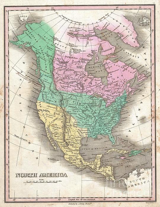
This is Finley’s desirable 1827 map of the North America. Covers the continent from Panama to the Arctic Circle, including Greenland, Iceland, and... more
Ships Within
3 - 4 business days
Protect your with an impact-resistant, slim-profile, hard-shell case. The image is printed directly onto the case and wrapped around the edges for a beautiful presentation. Simply snap the case onto your for instant protection and direct access to all of the phone's features!
Average Rating (4.68 Stars):


Chad Hop
April 27th, 2024

Love it! Case looks great on my new phone.
Jean Painter
April 27th, 2024

Love love this print
Barbara Strawbridge
April 26th, 2024

I love the unique phone case. Adele is a wonderful artist.
Ron Rogers
April 25th, 2024

The Porsche logo is not in the middle of the cover...I have always been proud to show my previous Porsche phone covers ...this one looks like a mistake...can you fix it?
Heather Griffith
April 24th, 2024

Not received
Robert Naile
April 21st, 2024

Just what I wanted for a new iPhone. A special “Thank You” to artist ‘Serge Averbukh’ for the addition, at my request, to the design of my Navy rating, the lightening bolts (sparks as they are/were called) in the middle of the CPO insignia. I asked; he came through….When I use my phone, it brings back fond memories of my 20-year Navy career…. Thanks Serge….
This is Finley’s desirable 1827 map of the North America. Covers the continent from Panama to the Arctic Circle, including Greenland, Iceland, and the northwestern tip of Asia. Color coding according to country. Shows U.S. claims to British Columbia prior to the 1818 compromise that set the boundary at the 49th parallel. Border compromise added by original owner in manuscript annotation. Also shows Mexico's claims to Upper California, here labeled New Albion and Unexplored Territory. Finley curiously charts two lakes in the Great Basin, one labeled Timpanagos and another smaller lake further south labeled Salt Lake. The Great Salt Lake is said to have first been seen by Europeans in 1824, only a few years before this map was published, so it is unlikely that Finley drew from this exploration. Instead, Finely is following Escalante's discoveries as recorded on the Miera map. The Escalante expedition actually visited Utah Lake (Timpanagos), but only heard about the Great Salt Lake from...
My passion is Photography and Aviation or is that Aviation and Photography ! I hope you enjoy my photographs.

Our return policy is very simple:
If you're not happy with a purchase that you made on FineArtAmerica.com, for any reason, you can return it to us within 30 days of the order date. As soon as it arrives, we'll issue a full refund for the entire purchase price. Please note - Fine Art America does not reimburse the outgoing or return shipping charges unless the return is due to a defect in quality.
Fine Art America sells thousands of pieces of artwork each month - all with a 100% money-back guarantee. We take great pride in the fact that hundreds of thousands of artists have chosen Fine Art America to fulfill their orders, and we look forward to helping you select your next piece!
All iphone cases ship from our production facility within 3 - 4 business days of your order.
$27.00


There are no comments for 1827 Finley Map of North America. Click here to post the first comment.