Looking for design inspiration? Browse our curated collections!

Boundary: Bleed area may not be visible.

The watermark at the lower right corner of the image will not appear on the final product.
Inside Message (Optional)
Inside View

by Paul Fearn
$6.45
Quantity
The more you buy... the more you save.
Orientation
Image Size
Product Details
Our greeting cards are 5" x 7" in size and are produced on digital offset printers using 100 lb. paper stock. Each card is coated with a UV protectant on the outside surface which produces a semi-gloss finish. The inside of each card has a matte white finish and can be customized with your own message up to 500 characters in length. Each card comes with a white envelope for mailing or gift giving.
Design Details
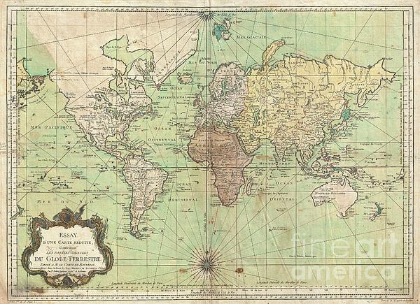
An attractive first edition first state example of J. N. Bellin’s 1778 nautical chart of the world. Presents the entire world on a Mercator... more
Ships Within
2 - 3 business days
Average Rating (4.84 Stars):


Constance Harper
April 26th, 2024

Very beautiful painting! Love the greeting cards!
Paul Cutright
April 25th, 2024

I loved the card. Message inside was perfect (just like I requested) Only comment - the picture seemed too large for the card (glue showing on the side) Next time I will down size the picture. I have ordered many cards from fineartamerica and have been very pleased with the artist selection and quality of the art. Paul Cutright
Sitara Laurenti
April 25th, 2024

Gorgeous!! rich colors, lovely glossy finish.
Sitara Laurenti
April 25th, 2024

Beautiful..lovely gloss finish, vibrant colors and amazing details
Kathleen Sanford
April 24th, 2024

Loved this! Colors not quite as bright as what you are showing but I still loved it!
Kathleen Sanford
April 24th, 2024

I thought the colors could have been a little brighter but I was happy with the product!
An attractive first edition first state example of J. N. Bellin’s 1778 nautical chart of the world. Presents the entire world on a Mercator Projection based on a Paris (L’Isle de Fer) meridian. This is notably the first state of this important map, exhibiting a pre-Cook geography throughout, but most specifically in the Pacific and along the northwest coast of America. North America to the west of the Mississippi is vaguely rendered according to 16th century expeditions into the region by Coronado, La Salle, De Soto, and others. Bellin identifies the semi-mythical civilizations of Quivira and Teguayo, both associated with legends of the Seven Cities of Gold, in what is modern day Utah, California, and Nevada. Along the western coast the strait discovered by Martin Aguilar is noted. Further north still the River of the West (Fl. de l’Ouest) extends from the west coast to the Lake of the Woods (Lac de Bois) and thence via additional waterways to the Great Lakes and the Atlantic. Th...
My passion is Photography and Aviation or is that Aviation and Photography ! I hope you enjoy my photographs.

Our return policy is very simple:
If you're not happy with a purchase that you made on FineArtAmerica.com, for any reason, you can return it to us within 30 days of the order date. As soon as it arrives, we'll issue a full refund for the entire purchase price. Please note - Fine Art America does not reimburse the outgoing or return shipping charges unless the return is due to a defect in quality.
Fine Art America sells thousands of pieces of artwork each month - all with a 100% money-back guarantee. We take great pride in the fact that hundreds of thousands of artists have chosen Fine Art America to fulfill their orders, and we look forward to helping you select your next piece!
All greeting cards ship from our production facility within 2 - 3 business days of your order.
$6.45


There are no comments for 1778 Bellin Nautical Chart or Map of the World. Click here to post the first comment.