Looking for design inspiration? Browse our curated collections!

Boundary: Bleed area may not be visible.

The watermark at the lower right corner of the image will not appear on the final product.
Inside Message (Optional)
Inside View

by Paul Fearn
$6.45
Quantity
The more you buy... the more you save.
Orientation
Image Size
Product Details
Our greeting cards are 5" x 7" in size and are produced on digital offset printers using 100 lb. paper stock. Each card is coated with a UV protectant on the outside surface which produces a semi-gloss finish. The inside of each card has a matte white finish and can be customized with your own message up to 500 characters in length. Each card comes with a white envelope for mailing or gift giving.
Design Details
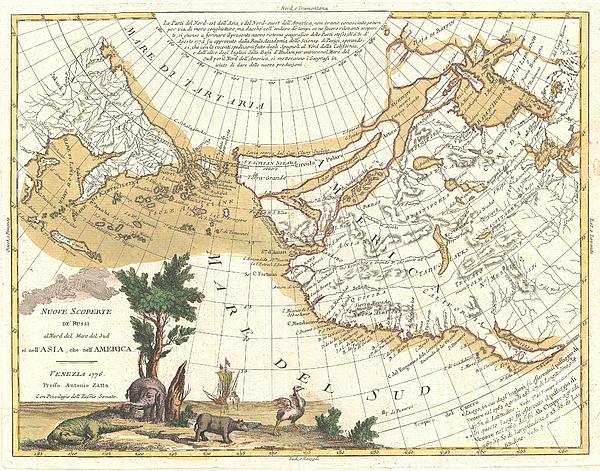
An exceptionally stunning example of Antonio Zatta's 1776 map of the northwestern parts of America and the northeastern parts of Asia. This map is... more
Ships Within
2 - 3 business days
Average Rating (4.84 Stars):


Sitara Laurenti
April 25th, 2024

Gorgeous!! rich colors, lovely glossy finish.
Sitara Laurenti
April 25th, 2024

Beautiful..lovely gloss finish, vibrant colors and amazing details
Kathleen Sanford
April 24th, 2024

Loved this! Colors not quite as bright as what you are showing but I still loved it!
Kathleen Sanford
April 24th, 2024

I thought the colors could have been a little brighter but I was happy with the product!
Debbie Ellliott
April 23rd, 2024

Lovely. Colors are true. Plan to purchase same image in a larger size.
Sherry Taylor
April 23rd, 2024

Most precious card I've ever Boughton!! Thank you for such Excellent service & fast turnaround pleased A++
An exceptionally stunning example of Antonio Zatta's 1776 map of the northwestern parts of America and the northeastern parts of Asia. This map is one of the most sought after and decorative 18th century pre-Cook maps of the Pacific Northwest ever issued. Covers the region from the Hudson Bay and the Great Lakes westward as far as Siberia and Japan, north well into the Arctic, and southwards as far as Cabo San Lucas in Baja California. In this stunning map, Zatta, combining almost every 17th and 18th century myth and fact of the American west into a single map, offers up a veritable smorgasbord of speculative geography. The idea of a Northwest Passage linking the Hudson Bay to the Pacific is central to this map. In this Zatta embraces the speculative geography advocated by Nicholas De L'Isle and Phillipe Bauche. De L'Isle and Bauche were supporters of the Northwest Passage theory associated with the apocryphal voyage of the 17th century Admiral de Fonte. The De Fonte legend first appe...
My passion is Photography and Aviation or is that Aviation and Photography ! I hope you enjoy my photographs.

Our return policy is very simple:
If you're not happy with a purchase that you made on FineArtAmerica.com, for any reason, you can return it to us within 30 days of the order date. As soon as it arrives, we'll issue a full refund for the entire purchase price. Please note - Fine Art America does not reimburse the outgoing or return shipping charges unless the return is due to a defect in quality.
Fine Art America sells thousands of pieces of artwork each month - all with a 100% money-back guarantee. We take great pride in the fact that hundreds of thousands of artists have chosen Fine Art America to fulfill their orders, and we look forward to helping you select your next piece!
All greeting cards ship from our production facility within 2 - 3 business days of your order.
$6.45


There are no comments for 1776 Zatta Map of California and the Western Parts of North America. Click here to post the first comment.