Looking for design inspiration? Browse our curated collections!

Boundary: Bleed area may not be visible.

The watermark at the lower right corner of the image will not appear on the final product.
Inside Message (Optional)
Inside View

by Paul Fearn
$6.45
Quantity
The more you buy... the more you save.
Orientation
Image Size
Product Details
Our greeting cards are 5" x 7" in size and are produced on digital offset printers using 100 lb. paper stock. Each card is coated with a UV protectant on the outside surface which produces a semi-gloss finish. The inside of each card has a matte white finish and can be customized with your own message up to 500 characters in length. Each card comes with a white envelope for mailing or gift giving.
Design Details
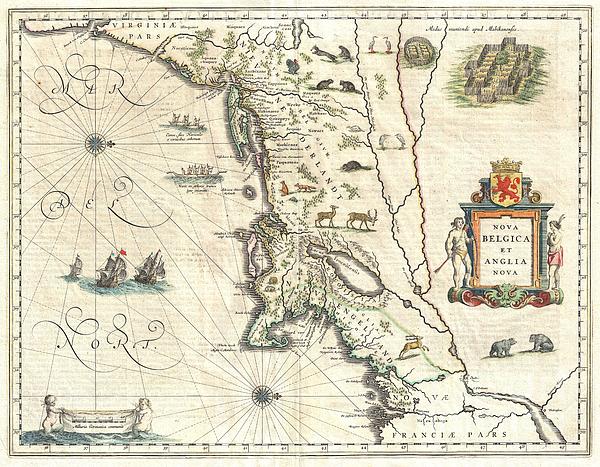
A beautiful old color example of one of the most important maps in the history of America, Blaeu’s c. 1635 Nova Belgica et Anglia Nova . Oriented... more
Ships Within
2 - 3 business days
Average Rating (4.84 Stars):


Sitara Laurenti
April 25th, 2024

Gorgeous!! rich colors, lovely glossy finish.
Sitara Laurenti
April 25th, 2024

Beautiful..lovely gloss finish, vibrant colors and amazing details
Kathleen Sanford
April 24th, 2024

Loved this! Colors not quite as bright as what you are showing but I still loved it!
Kathleen Sanford
April 24th, 2024

I thought the colors could have been a little brighter but I was happy with the product!
Debbie Ellliott
April 23rd, 2024

Lovely. Colors are true. Plan to purchase same image in a larger size.
Sherry Taylor
April 23rd, 2024

Most precious card I've ever Boughton!! Thank you for such Excellent service & fast turnaround pleased A++
A beautiful old color example of one of the most important maps in the history of America, Blaeu’s c. 1635 Nova Belgica et Anglia Nova . Oriented to the west, this map covers the American coast from Virginia, past New York and Long Island to Cape Code, New England, and Quebec. It is cartographically derived from data accumulated by Adriaen Bock and other Dutch fur traders active in the early 17th century. It is known for a number of important firsts, including the first full representation of Manhattan as an Island. Burden, in his Mapping of North America , notes: This important map was one of the most attractive of the Americas at the time. It is noted for the fact that its primary source is the first manuscript figurative map of Adriaen Block, 1614. Indeed it is the first full representation of it in print. It is one of the earliest to name Nieu Amsterdam. Block, a Dutch fur trader, explored the area between Cape Cod and Manhattan, examining the bays and rivers along the way. This...
My passion is Photography and Aviation or is that Aviation and Photography ! I hope you enjoy my photographs.

Our return policy is very simple:
If you're not happy with a purchase that you made on FineArtAmerica.com, for any reason, you can return it to us within 30 days of the order date. As soon as it arrives, we'll issue a full refund for the entire purchase price. Please note - Fine Art America does not reimburse the outgoing or return shipping charges unless the return is due to a defect in quality.
Fine Art America sells thousands of pieces of artwork each month - all with a 100% money-back guarantee. We take great pride in the fact that hundreds of thousands of artists have chosen Fine Art America to fulfill their orders, and we look forward to helping you select your next piece!
All greeting cards ship from our production facility within 2 - 3 business days of your order.
$6.45


There are no comments for 1635 Blaeu Map of New England and New York. Click here to post the first comment.